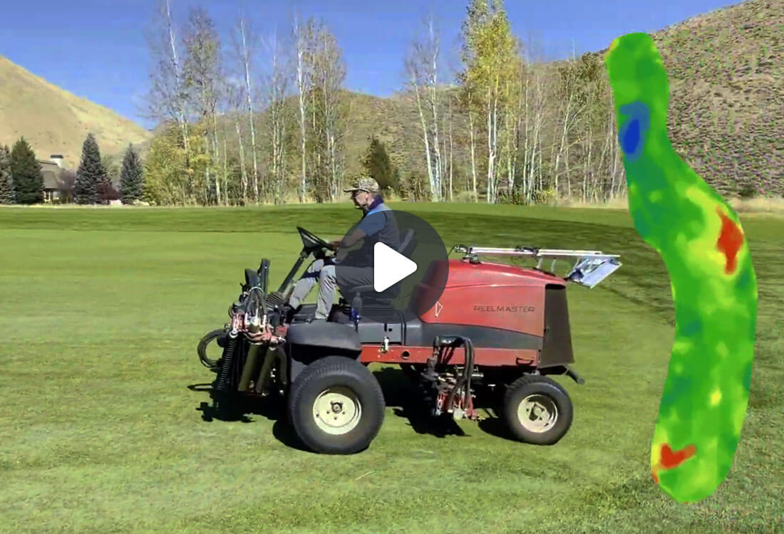
At taskTracker, we always focus on providing the best solution for the Superintendent. Collecting and acting on moisture data can have a huge impact on course playability, water savings, chemical applications, and labor. That is why we are excited to be the exclusive partners with TerraRad Tech. Their turfRad sensor can take 14 moisture readings per second without the need to fly a drone or stick a probe in the ground. Learn how taking moisture readings can have an ROI of 400-600%.
TURFRAD + ASB TASKTRACKER
Better Playability, Reduced Watering, and Real Savings
You really can have it all with a simple and easy scan. The high-resolution moisture maps and irrigation suggestions will take the stress out of managing your water.
TURFRAD RADIOMETER SENSOR
Effortless Setup, Amazing Clarity and Timely Insights
Roll into the future of soil moisture sensing for golf course and turfgrass management. The sensor takes the measurements so that you can focus on decisions.
Save Water, Energy, and Fertilizer for a Sustainable Future
Passive Data Collection
Moisture Comparisons
Irrigation Suggestions
Area Threshold Details
The Technology
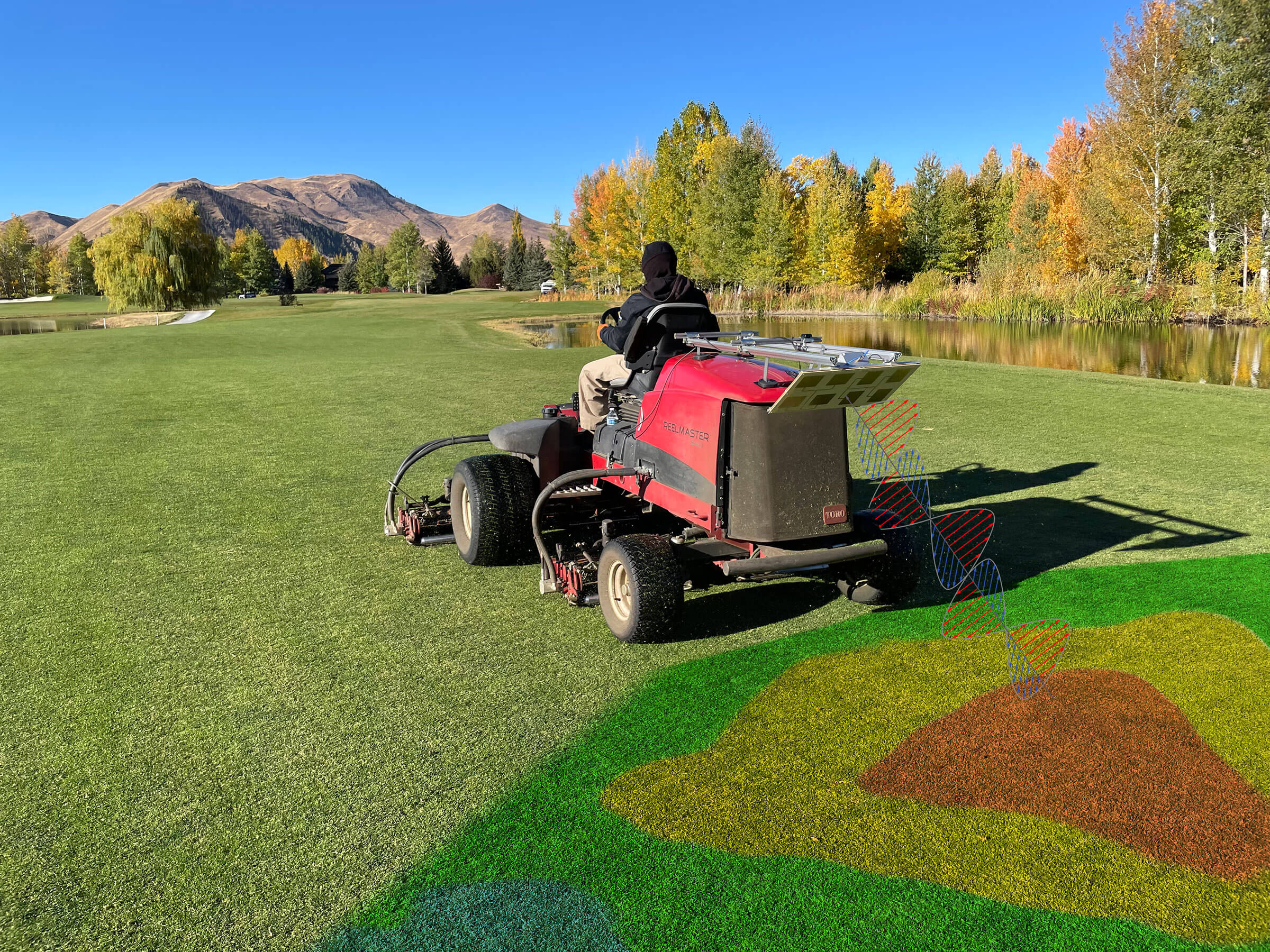
To bring you this game-changing technology, we partnered with TerraRad Tech, an environmental remote-sensing technology company. Their passive microwave remote sensor, turfRad, is based on satellite remote sensing technologies, measuring naturally emitted microwaves from the soil. The data captured with the remote sensor can be used to optimize irrigation prescriptions, save water, and increase consistency.
The radiometer remote sensor is mounted on the mower using a universal mounting structure. While mowing, it measures soil moisture 14 times a second at a depth of 4 inches, creating a measurement every square foot if you are traveling at 10 MPH. The sensor isn’t just limited to fairway units. It can mount onto any vehicle and take measurements at any speed. Sensors can also be placed in an array to provide a broader coverage per pass.
How it Works
You will be passively collecting soil moisture samples every time your mowers are out with the mounted radiometer remote sensor.
The data will be uploaded automatically over Wi-Fi after you’re done mowing and will be available within 1 hour. It provides you alerts for specific thresholds that you set per zone. You can use those soil moisture maps to program your irrigation system.
With accurate and precise moisture maps, you will know which heads need to water and which do not. You’ll be able to recognize heads that are stuck or need to be turned off before you start losing turf. You’ll also be able to better manage hot spots and plan for better drainage. It all starts with precision measurements.
Questions and Answers
Hardware
Is it possible to mount on a cart? If so, what is the maximum width of the pass for the sensor? Being we may mow fairways once weekly, we need to use another vehicle for collecting data.
Yes. The resolution of the interpolated map depends on the pass width. We have options for multiple sensor arrays to increase the width per pass and cut down on scan time. The sensor(s) can mount on a maintenance cart in single or array configuration as an alternative to the fairway mowing unit mount.
Do you see this being put on triplex units for greens?
Yes. There is no reason why not. Most of our customers are interested in fairways because they are the biggest piece of real estate and typically use the most water, but we can measure all the zones of your golf course; fairways, tees, rough, greens, and even bunkers.
What is the sampling technique for those walk-mowing greens?
We do not yet have experience with using the turfRad sensor with walk mowers. We will be putting this on our to-do list for this summer and will get back to you with our recommended technique.
Sensor Operation
Can multiple sensors be employed when mowing large acreages with multiple machines?
Yes, multiple sensors can be used on the same fairway mowing in parallel. Each time a new sensor uploads data the maps are re-interpolated and new data is added to each fairway.
Can the sensors be removed or stowed easily to prevent damage when fairway mowers are not in use? How quickly can a replacement sensor be provided?
The sensor mount uses magnets to the unit making the sensor easily removable. In addition the mount will fold up so the sensor fits within the footprint of the mower protecting it from accidentally being hit.
Are they ok to get wet? Whether that be from rain or simply washing the equipment?
Yes. They are in a fully waterproof enclosure.
Is this technology available on a drone to cover more area with less sensors?
Yes, that’s an option but for golf we recommend using two or three sensors, either on one maintenance cart or on multiple mowers to provide consistent conditions independent of weather and time of day.
Can the sensor collect data in the dark? i.e., early morning ahead of sunrise?
Yes, unlike all forms of visual inspection, turfRad can work 24 hours a day.
Software
How would updates work?
Updates are pushed via WiFi with over-the-air (OTA) remote updates. We will constantly keep your sensor up-to-date with the newest firmware.
Do you need a map already or does it use Google Earth?
We can use an existing drone image or high resolution satellite overlay, or if you do not have this we will use standard satellite imagery similar to Google Earth.
Will turfRad integrate with the Toro Lynx map?
Not yet but we are working closely with our contacts at Toro as they also look to improve their integration with external products. The goal is to be automatically feeding irrigation prescriptions across Toro, Rainbird, and Hunter systems within 1-2 years.
If we have an RTK Drone map of our course you would be able to utilize that with the software?
Yes, we can take any format of georeferenced drone imagery and convert this to a geotiff / tileset that will act as your basemap when viewing moisture maps. Our example from The Valley Club uses exactly this. Hunter systems within 1-2 years.
Data Visualization
Having this data should be a fundamental baseline measurement. I can see this supporting our water use, input use relative to weather, permitting and stewardship. Cost is an insurance piece.
We agree that this should be a baseline measurement for all superintendents trying to improve upon their resource use.
Does soil or water salinity affect measurements?
The microwave frequencies we use are much less impacted by salinity than lower frequency probes (e.g. TDR) and capacitive sensors where conductivity plays a larger role in the measurement. The impact of salinity should be minimal.
Does dew affect the sensor's abiltiy to take measurements?
Our sensor will see the total amount of water in its field of view down to about 4 inches, however the total volume of water present in dew is quite low compared to the amount of water contained in this upper layer of soil. Dew will have a negligible impact on the soil moisture readings.
What is the max mph you can go and get accurate readings?
Speed does not affect the accuracy of the reading, however the faster the vehicle is traveling the more distance between measurements. 7 miles an hour would give a measurement every foot.
How much variation of measurement is there with your technology compared to others?
If we sampled a fairway with POGO (we sample on a 12-pace grid) and turfRad, what difference would we find in the data? We would expect the turfRad sensor to provide similar spatial patterns to the interpolated point measurements, but with much greater resolution, due to having a measurement every foot instead of every 12 paces. The turfRad measurements would also have less variance as the effective sampled soil volume is larger and is not as susceptible to small-scale soil heterogeneity.
”"As superintendents, we're constantly being reactive; we're always going out and looking at areas that are too dry or too wet. What I like about this, is being able to see how it's trending; if it's getting too wet on the front of the fairway, or if it's getting a little dry on the back of the fairway. It is nice to monitor moisture every day and make tiny adjustments to our irrigation system so we are trending the proper direction."
Gerald FlahertyCo-Founder at taskTracker & CGCS at The Valley Club, ID